Faults and Lineations.
The Northwestern Siberian Study Roundup
Author: A.G.Repin
Publisher: Otechestvennaya Geologiya 1/2005, p.37-41 ISSN 0869-7175
English Translation: Philip Aghion
A note on the article from the author and Terra Exploro Group.
This in-depth article is dedicated to the geological scientific community. This column intends to whip up a discussion and arouse geologists' interest in the techniques that Terra Exploro has been utilizing for over a decade now in its oil prospecting projects.
The issue of faults found in tectonic plates' sedimentary covers is still an indispensable one in geological circles. A naumber of prominent twentieth century geologists formed the opinion that faults can only exist in consolidated rock formation of plate's foundation, but not in deposits.
This point of view was based on the analysis of mountain regions where the faults are crucial geological features which shape both the geological structure and all the specific features of these regions' contemporary relief. Despite being hidden from surface view, sedimentary basins were studied for a long time only by random drilling and low-resolving geophysical methods.
Western Siberia's current tectonic structure models have been built on a fairly small number of drilled bore holes, so, regional and local ideas were completely rooted in the tectonic folding conception. Veteran geologists see these faults in the sedimentary cover as a unique and local phenomenon.
Currently, oil-industry geologists map out faults in reservoir locations in layers at different depths. Even though large volumes of geological and seismic materials, as well as data acquired by interpreting the materials of remote sensing reveal many faults in the basin, debate still rages over its preciseness.
When it comes to construction of the models, field geologists are faced with the additional dilemma of what to separate and how to show the results.
From the author's point of view, present geological modes and terms must be clearly defined and set straight. Therefore, by applying that to our case, faults in the deposits are somewhat different than faults in the magmatic and metamorphic rock.
Glossary of Terms:
FAULT - is a geological theoretical concept: group of models characterized earth crust's breakness-unity. The author's position:
1. A fault is a flat geological feature with low thickness that crosses natural sediment position of layers. It is separated on the basis of the geophysical, geological, geochemical parameters in the deposits.
2. Yet, simultaneously, faults always form a boundary.
3. The scope of geological works affects the results, models - maps, sections, etc. When seen as a complete unit, faults become prominent with a research scale ratio of less than 1:100 000.
4. Fault - as a “linear” result of tensions within the limits of section or region of the earth's crust.
5. Faults have own geological histories (breakings – don't have any).
6. Faults in deposits are always form a series of fault systems and different types of folds.
7. Tectonic movements (vertical and horizontal) always form a series of, fault systems and various types of folds. During the research process we usually show fault zones - fault-fold-system (FFS) on a small scale maps. Some Russian specialists coined a term for the FFS - "dizplikat".
8. FFS determines the special features of the landscape of surface.
LINEATION - this term doesn't have a clear definition. In author's position the most appropriate definition is the line on any geological map (or other image) which reflects the intersection of the fault and the earth's surface.
Reseach Methods Applied.
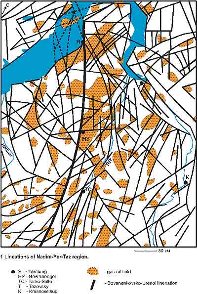
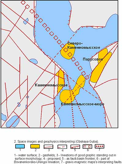
Spotting lineations in the region was based on deciphering of remote sensing materials (LANSAT-7 and other images). Moreover, joint interpretations of the remote sensing materials, seismic surveys, and magnetic surveys in the individual sections of territory were conducted. Consequently, the maps of petroleum and gas fields were compared with the maps of lineations, which led to the following outcomes, indicated below.
Results.
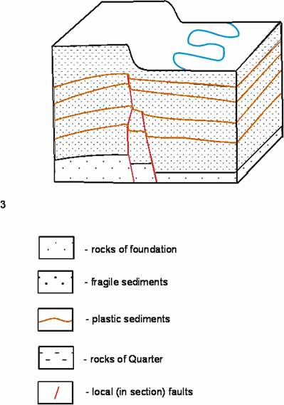
The author showed just how consistently the linear formations had coincided with existing reservoirs. (pic. 1,2). Picture 3 explains this observation. When parts of plates - blocks of deposits including rock foundations - under influence of tectonic movements, the folds form in plastic rocks, a series of localized “little faults” and breakings - in fragile rocks: that is how the fault (fault zone) is structured on plates with the thickness of sedimentary cover in section (pic.3.)
Conclusions.
1. Through his research, the author has not only proven but also upheld many geologists' ideas of the paragenetic connection of folds and breakings as accurately valid interpertations.
2. The horizontal motions of fluids (filtration) in the earth's crust can be concentrated in the breaking zones, the places of the expansion of local folds where gas, oil, and water can accumulate.
3. Deciphering and interpretation of satellite images using the author's techniques can lead to cost reduction in localized search operations and optimizing geological and geophysical exploration, prospecting.
Diagrams:
Sources:
1. Repin A.G. Desiphering as a scientific system. Izvestya RAN, ser. Geogr., May-June, 1993 pp.102-109.

Article Highlights:
“Western Siberia's current tectonic structure models have been built on a failry small number of drilled bore holes, so, regional and local ideas were completely rooted in the tectonic folding conception. Veteran geologists see these faults in the sedimentary cover as a unique and local phenomenon.””
““...present geological modes and terms must be clearly defined and set straight. Therefore, by applying that to our case, faults in the deposits are somewhat different than faults in the magmatic and metamorphic rock.”
“Through his research, the author has not only proven but also upheld many geologists' ideas of the paragenetic connection of folds and breakings as accurately valid interpertations.”
“Deciphering and interpretation of satellite images using the author's techniques can lead to cost reduction in localized search operations and optimizing geological and geophysical exploration, prospecting.”
Terra Exploro
GLOBAL petroleum PROSPECTING
AND EXPLORATION